

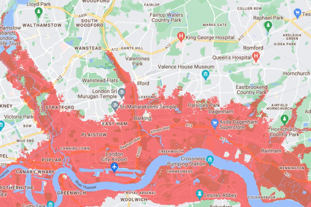
Significant parts of east London will be underwater within a decade, an interactive map has revealed.
Swathes of Hornchurch, Rainham, Stratford, Ilford, Barking and Dagenham will be underwater in 2030, according to data from nonprofit research publication Climate Central.
The map, in red, shows the land projected to be below the annual flood level in 2030, showing the potential impact of sea level rise and coastal floods.
On September 20, Prime Minister Rishi Sunak rowed back on major climate change commitments, including the delay to phasing out the sale of new petrol and diesel cars to 2035 from 2030.
Cllr Keith Darvill, Havering Council's cabinet member for climate change, said a "dramatic" situation could develop in London and he was "disappointed" in the Government's announcement.

"You could really have a dramatic situation in London", he said. "We've got specific concerns about our own borough, [so] obviously we need to build resilience."
"It's very poor planning from the government's point of view - if they pull away from that [climate goals] and investment is not there you won't get the same interest from business."
RELATED NEWS: 'Silent disco meets David Attenborough' show set for Havering
Cllr Darvill said government delays would put off businesses looking to invest in the green economy, limiting the ability of borough's such as Havering to spend on climate change measures.
All the while the risk of floods is increasing, Cllr Darvill added.
"Some of the floods we've had have been termed as once in 100 years, but we've had two in 20 years," he said.
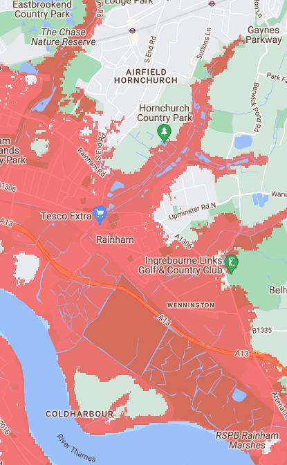
Rainham plays a crucial role in flood prevention, Cllr Darvill said, by relieving flood water from the river Thames into its marshes.
"There's no easy solution other than it's got to be a priority issue for the borough in its climate change planning," he added.

The interactive map shows the vital role Rainham plays in protecting the surrounding area from floods.
In 2021, 40mm (1.5 inches) of rain fell in an hour on June 25, the highest amount in the borough since 2016 according to Havering Council, causing serious flooding.
Jon Cruddas, MP for Barking and Dagenham, spoke about the disruption to families who were forced out of their homes by repeated floods in 2016, 2020 and 2021.
"This must not be allowed to happen again," Mr Cruddas told The Recorder in 2021.
Cllr Darvill said Havering was trying to become climate neutral by 2040, but said more funding was needed from central government.
He added that Havering needs its properties to be properly retrofitted to make homes more energy efficient and reduce costs for council tenants.
The Department for Energy Security for Net Zero said Mr Sunak made clear that plans to meet the goal will only succeed if public support is maintained, and vows to take a realistic path to reach net zero by 2050.
Based on peer-reviewed science in leading journals, Climate Central has stressed its maps include large datasets, "which always include some error".
It has also warned that estimates do not account for man-made structures to prevent further damage including seawalls, meaning some areas will not face the expected scale of damage.


Comments: Our rules
We want our comments to be a lively and valuable part of our community - a place where readers can debate and engage with the most important local issues. The ability to comment on our stories is a privilege, not a right, however, and that privilege may be withdrawn if it is abused or misused.
Please report any comments that break our rules.
Read the rules here